Every cloud has a silver lining—and in aviation, understanding this can reveal critical climate insights. In his paper “Contrails and Cirrus Clouds: Aviation’s Non-CO2 Impact on Climate”, Matthias Tesche, researcher from University of Leipzig and the SESAR AEROPLANE project, explores how aircraft-induced contrails and embedded contrails within cirrus clouds affect our atmosphere.
Beyond CO2 emissions, these contrails alter the radiative properties of clouds, contributing to atmospheric warming. Using spaceborne lidar technology and extensive aircraft data, Tesche quantifies these impacts, highlighting the need for comprehensive climate models that consider these significant but often overlooked effects of aviation on our environment.
Contrails and cirrus clouds: an aviation’s non-CO2 impact on climate
Author: Matthias Tesche (UniLeipzig)
Aviation affects Earth’s energy balance in multiple ways. Besides the emission of exhaust gases and soot, it also causes non-CO2 effects. Best known is the formation of optically thin contrails and contrail cirrus that can be detected in passive remote-sensing observations from space and have a warming effect on the atmosphere. However, aircraft might also fly through already existing cirrus and lead to the formation of contrails embedded in these clouds.
Today, we have little knowledge of how those embedded contrails affect the radiative forcing of natural cirrus clouds – an entirely unquantified non-CO2 effect of aviation that will be addressed in AEROPLANE. Specifically, we expand on the initial studies of Tesche et al. (2016) and Marjani et al. (2022) who focused on only three connections between the US West Coast and Hawaii.
Embedded contrails in cirrus clouds
The investigation of embedded contrails within AEROPLANE is based on active remote-sensing observations with spaceborne lidar. This technique uses a laser beam to penetrate optically thin clouds to obtain height-resolved information depending on the attenuation of the emitted light. As a result, it is possible not only to detect a cirrus cloud, but also to gain insights into what happens exactly at the flight level of an aircraft that might have passed through the cloud.
To find such instances of embedded contrails and to assess their impact on natural cirrus, partners at Leipzig University have developed a tool for finding intercepts between the actual location of individual aircraft and the position of the CALIPSO satellite that carries a spaceborne lidar. Within AEROPLANE, we are using 21 months of aircraft position data provided in the EUROCONTROL R&D data set.

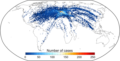
Figure 1. Map of the likely occurrence of contrails that formed in already existing cirrus clouds as identified from matching the position of individual aircraft in the EUROCONTROL R&D data set (2015 – 2021, 28 months of data) with spaceborne lidar observations of cirrus clouds at flight level of the respective aircraft.
The search for intercepts considers geographical location, height, and time difference. Found intercepts have to fulfil the following criteria: the time delay between aircraft and satellite passage (or vice versa) should not exceed 30 minutes, a cirrus cloud has to be present in the lidar observation at flight level, and the lidar data have to pass a set of quality-control measures to be suitable for further analysis. An overview of the distribution of cases that will be considered in our analysis is provided in Figure 1.
What’s the impact of embedded contrails?
The analysis of the effect of embedded contrails on natural cirrus clouds is based on a simple idea similar to those of ship tracks in low-level stratus clouds over the ocean. The passage of an aircraft leads to a perturbance of the cirrus clouds that can be contrasted to natural conditions. In our case, observations at intercepts of an aircraft and the satellite’s ground track can be stratified according to instances when observations took place before and after an aircraft has passed through a cirrus cloud. The former would represent the natural cloud, while the latter should show signs of a perturbation related to the passing aircraft.
A similar effect can be resolved when contrasting satellite observation in close proximity the an aircraft’s passage with those further away during the same overpass. Prior research has shown that perturbations related to embedded contrails manifest in an increase of the cloud’s optical thickness which would make the cloud appear brighter – though not as pronounced as in the case of ship tracks.
Freshly formed embedded contrails are essentially contrails superimposed on natural cirrus. Before contrail ice removal via aggregation within hours after formation, embedded contrails lead to a local decrease in ice crystal effective radius, as well as a local increase in ice crystal number concentration and extinction coefficient compared to the unperturbed cloud. These factors cause an increase in cloud optical thickness which in turn determines the radiative effect of the cloud. The aim of our observation-based quantification of the aviation-induced change in the optical and microphysical properties of cirrus clouds is to bound the impact of embedded contrails on the radiative properties of affected cirrus clouds.

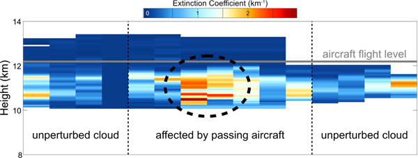
Figure 2. Example for the detection of embedded contrails based on CALIPSO lidar observations of the extinction coefficient within a cirrus cloud about 17 minutes after the passage of an aircraft (around which the plot is centered) at a height of 12.2 km (grey line). Dashed lines separate the region in close proximity to the aircraft’s location to observations further away and assumed to be unperturbed. The dashed circle highlights an increase in extinction coefficient that is attributed to the passing aircraft.
Figure 2 provides an example of how embedded contrails manifest in the considered lidar observations. Since also natural cirrus can show an inhomogeneous structure, we need information on the location and height at which an aircraft might have passed through the cloud. This allows for contrasting the pristine regions at the left and right sides of the plot from the perturbed region in close vicinity to the aircraft passage. Because contrails sink within their vortex phase, enhanced extinction coefficients appear within a few hundred meters below flight level. In contrast, an observation of a cirrus unpenetrated by an aircraft should show a more homogeneous distribution of extinction coefficients.
Understanding the contrails’ impact on the atmosphere and climate
Within the framework of AEROPLANE, we will compile a data set of cloud optical and microphysical properties related to embedded contrails depending on location and the time difference between aircraft passage and satellite observation. This data set will allow us to quantify the impact of aviation on already existing cirrus clouds, to assess potential saturation effects in regions of high air-traffic density, and to provide an estimate of the impact of embedded contrails on Earth’s radiative budget and, thus, climate.
