A.5. Civil–Military roadmap
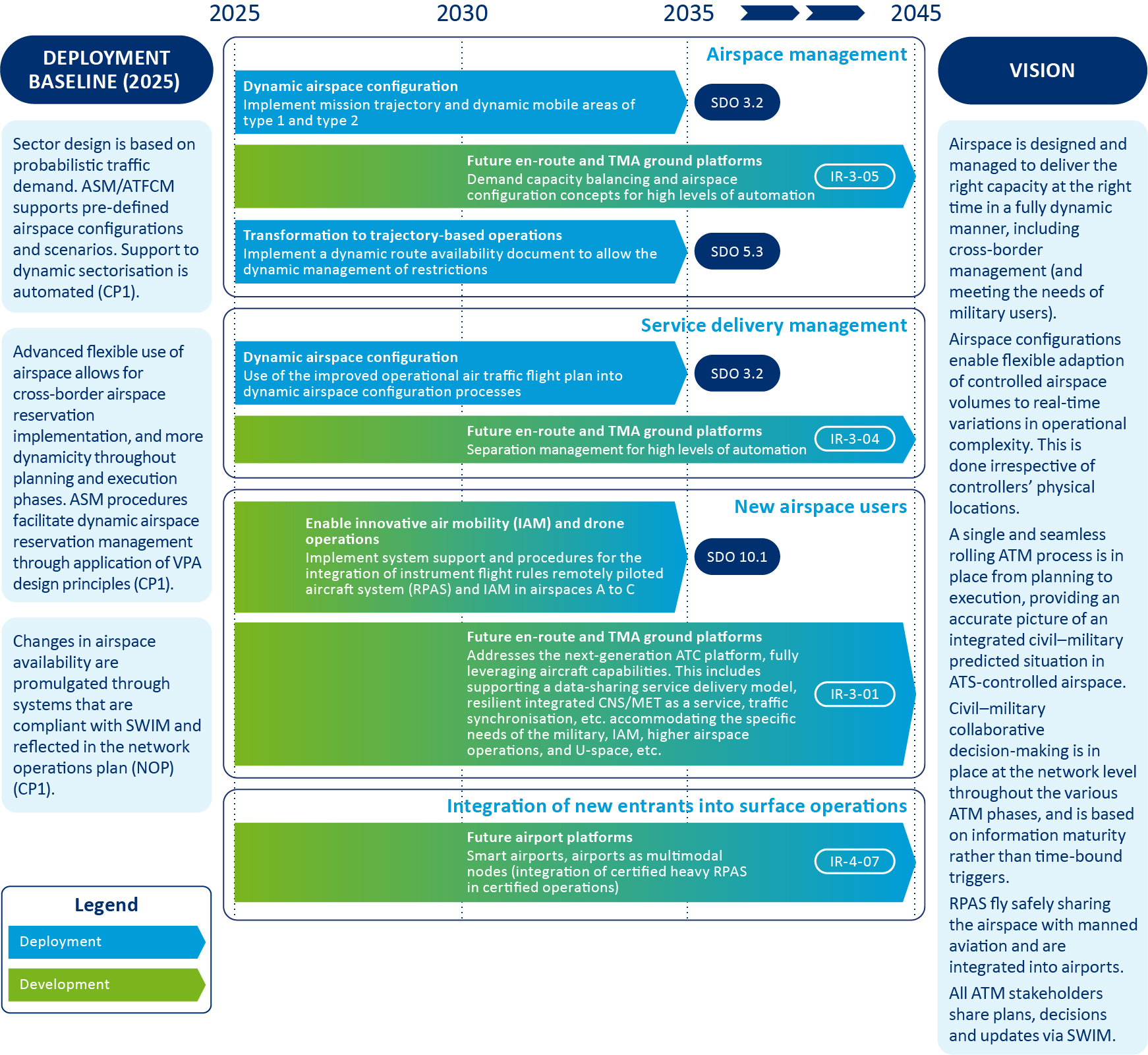
The roadmap in Figure 24 identifies priority civil–military capabilities (i.e. in terms of airspace, technology and data), which need to be developed and deployed to ensure the progressive airspace integration of envisaged future combat systems, including remotely piloted air systems (RPAS), in an interoperable manner and with additional efforts to ensure the robustness and resilience of cybersecurity. The air domain is critical to securing EU territories and their populations, as well as for international trade and travel. Effective civil–military cooperation, as reflected in this roadmap, is key to enhancing flight efficiency, optimising airspace capacity and safeguarding the military’s operational efficiency, as well as the effectiveness of military mission (i.e. planning versus activation). This cooperation is also critical for facilitating access to airspace for new military aerial vehicles (e.g. fifth-generation fighters, RPAS, high-altitude pseudo-satellites, balloons, etc.) in a sustainable, safe and secure aviation environment.
Military operations require unlimited access to airspace and airports with the support of a dual-use CNS infrastructure. Such CNS systems will accommodate military flights with required levels of air-ground two-way communication, high levels of advanced navigation steering and positioning, and surveillance identification and separation - in all cases with a high level of security and resilience. Connectivity through SWIM, access to data repositories and participation in TBO are essential.
Vision and key milestones for civil–military capabilities
By 2030, enhanced data sharing will be facilitated by predefined airspace structures, enabling more dynamic airspace management and free route airspace. This process necessitates higher levels of coordination between civil and military air navigation service providers (ANSPs), supported by dynamic civil–military collaborative decision-making (CDM).
Significant progress will have been made on development priorities affecting air–ground connectivity (including CNS dual use) and the level of automation for future en route, TMA and airport platforms (including the fully dynamic management of scalable airspace configurations to meet the needs of military users).
By 2035, the implementation of mission trajectory and dynamic mobile areas (DMAs) of types 1 and 2 will be completed, using the improved operational air traffic flight plan (iOAT) in dynamic airspace configuration processes, together with integration of instrument flight rules (IFR) RPAS into airspace classes A to C.
By 2045, all missions (crewed or uncrewed) – including those by supersonic, hypersonic and suborbital vehicles – will operate in a way that maximises to the fullest extent, aircraft capabilities to reduce the overall impact of aviation on the climate. Airspace will be designed and managed to deliver the right capacity at the right time in a fully dynamic manner, including cross-border management. A single and seamless rolling ATM process will be in place from planning to execution, providing an accurate picture of an integrated civil–military predicted situation in ATS-controlled airspace. Civil–military collaborative decision-making will be in place at the network level throughout the various ATM phases, based on information maturity rather than time bound.
With these developments, civil ANSPs in collaboration with the military can dynamically scale capacity up or down in line with demand while also taking into account military users. These capacity adjustments are implemented in real time and ensure an optimal and cost-efficient use of resources at any moment across the network (airspace, data, infrastructure and human–machine teaming). The continuous optimisation of every mission trajectory will also improve the civil use of released and available airspace (CURA) thanks to high connectivity between air–ground and ground–ground components.

Figure 24: Civil–Military roadmap
